Geography Class 37 [17:11:00]
A brief overview of the previous class i.e. Himalayas and Q&A session
The Peninsular Block [17:43:00]
- The peninsular block is a great complex of Ancient rocks which has existed as a single rigid block for Millions of years
- It extends from Gujarat in the west to Meghalaya in the east and from Plains in the north to the southern tip of India in the south
- [* Why did Meghalaya get separated?- A gap was formed named as "Malda gap" or "Garo-Rajmahal gap"]
-

- This region was subjected to a few episodes of Tectonic activity
- 1) Submergence of the Western part of Western Ghats
- 2) Formation of Rift Valleys such as Narmada-Tapi etc
- 3) Formation of Deccan traps when the Indian plate was moving towards the Eurasian plate and it encountered the Reunion Hotspots
-

Mountain ranges in Peninsular Block [18:02:00]
- Arvallis- Old fold mountains of earlier times
- Vindhyas and Satpuras- Block mountains
- From north to south- Vindhya> Satpura> Narmada> Tapi
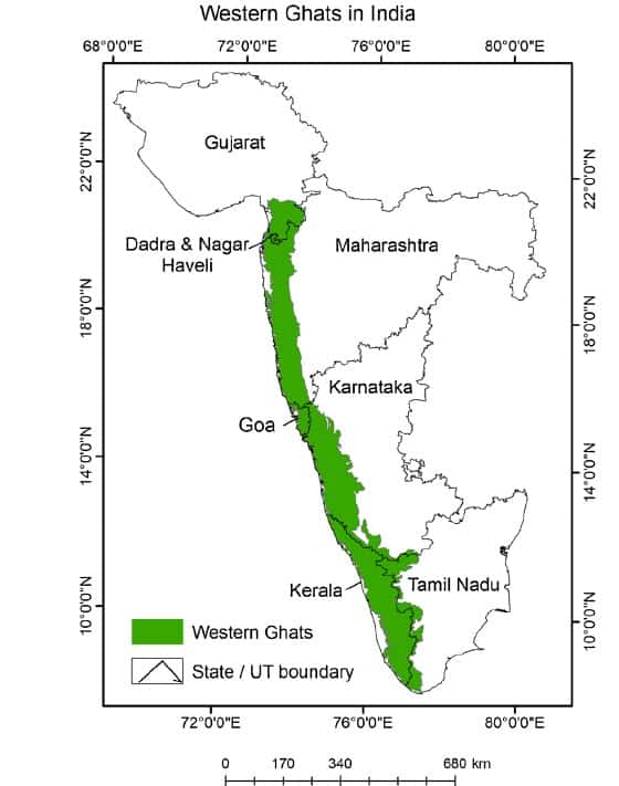
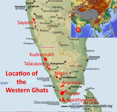
- Western Ghats
- Eastern Ghats
Western Ghat and Eastern Ghat comparison [18:05:00]
-
Western Ghats Eastern Ghats Extent Gujarat (south of Tapi) to kanyakumari South of Mahanadi to Nilgiri States Gujarat, Maharashtra, Goa, Karnataka, Kerala, Tamilnadu
Orissa, Andhra Pradesh, Telangana, Tamilnadu, Karnataka

Continuity Continuous Discontinuous
[* Due to the rivers coming from the west which has eroded the eastern Ghats]
Slope These are taller These are a bit shorter
Narrow Wide
Topography Highest peak- Anaimudi
Overall height increases towards the south
Highest peak- Mahendragiri
Some sources state that Zindgada's peak
Height increases towards the North
Closeness with coast Closer to the coast
A Bit far from the coast
Physiography More river originates from western Ghat
Less river originates from eastern Ghat
Precipitation Higher precipitation
Lower precipitation
Vegetation Vegetation in Western ghat is an evergreen type
Vegetation- Deciduous
Biodiversity Higher Biodiversity in Western Ghat
Lower biodiversity in Eastern Ghat
- Ghat means Pass [Palghat, Bhorghat] or highly elevated regions
- Parts of Western Ghats
- In Maharashtra and Karnataka- Called Sahayadri
- In Karnataka- Baba Budan Hills. It is the origin of coffee
- Nilgiri- Because of Neelkurinji Flowers
- Anaimalai Hills
- Cardamom Hills
-
- Parts of Eastern Ghats
- Mahendragiri
- Nallamala hills
- Palkonda Hills- Tirupati is part of this
- Javadi & Shevroy hills
-

Plateaus of Peninsular Block [18:25:00]
- Malwa plateau
- Bundelkhand Plateau
-
![Solved] Which one of the following plateaus is not a part of the Sou](https://storage.googleapis.com/tb-img/production/21/08/F1__Uma%20B_23-08-21_Savita_D3.png)
- Chotanagpur Plateau- Entire Jharkhand state
- Meghalaya Plateau- Garo, Khasi, and Jaintia hills are part of this plateau
- Deccan Plateau- Between Western Ghat and Eastern Ghat- Maharashtra, Karnataka, and Northern part of Telangana are covered in Deccan traps
- Rayalseema Plateau- Region within Andhra Pradesh. [* It is called Rayalseema because it was ruled by the Clan of Rayas ]
- Telangana plateau
- [Krishna river marks the boundary between Rayalseema and Telangana plateau]
- Karnataka plateau- Towards western ghat, it is a hilly region called Malnad and on the other side it is a plain region called Rolling plain/ Maidan
- Dandakarnya plains
Plains of India [18:36:00]
- Flat regions
- Two types- Northern Plains and Coastal Plains
- Northern Plains
- How it originated?
- The Northern Plains are formed by the deposition of sediments brought by the Himalayan rivers into the basin between the Himalayas and Peninsular blocks.
- It extends for a total of 3200 KMs of which plains of India are for 2400 KMs
- This is the largest alluvial plain in the world
- It is divided into the Rajasthan plain, Punjab& Haryana Plains, Ganga plains, and Brahmaputra Plains
-

Rajasthan Plains [19:10:00]
- It is a riverine plain
- It is formed due to sediments brought by the rivers
- They may have formed due to the drying up of the rivers which once existed in this region
- The western part of Rajasthan is a proper desert called "Marusthali"
- The eastern part of Rajasthan plains is called Rajasthan Bagar which is semi-arid due to the presence of river Luni
Punjab & Haryana Plains [19:20:00]
- These are the plains of the Indus
- Doab is a region between two rivers
-
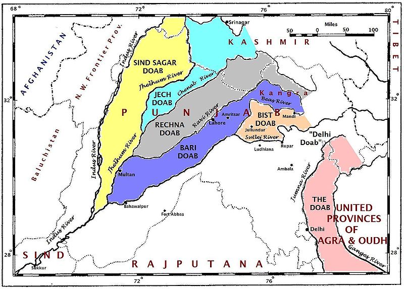
- BIST doab- between Beas and Sutlej rivers. It is only in India.
- BARI doab- Between Beas and Ravi rivers
- RECHNA doab- Between Ravi and Chenab
- CHAJ doab- Between Chenab and Jhelum
- Sind Sagar Doab- Between Sind and Chenab
Ganga plains [19:26:00]
- It covers UP, Bihar, and West Bengal
- It extends from Delhi to Kolkata
- Parts of the Ganga plains
- Doab- Ganga- Yamuna Doab
- Rohilkhand plains
- Awadh plains
- Lower Ganga plains
Brahmaputra Plains [19:31:00]
- It is also called the Assam plains
- Extent- From Sadiya in the east to Dhubri in west
- It is surrounded by Hills
Types of Northern Plains [19:35:00]
- Bhabhar-
- It is a region of Porous gravel and boulders deposited by rivers entering the plains from the Mountains
- In this region the smaller rivers disappear and start flowing underground
- Terai-
- It is a marshy region after Bhabhar where rivers start to re-appear. It is very fertile and widely used for the agriculture of rice and sugarcane
- They are waterlogged regions and are prone to water-borne diseases/ Mosquito-borne diseases
- Northern parts of UP, Bihar border, Nepal, Muzaffarnagar area.
-
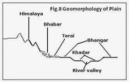
- Khadar
- It is the alluvial plain just next to River valley.
- It is made up of fresh alluvial soil which gets replenished every year
- It is more fertile
- Bangar
- It is the older alluvial plain located away from the river valley
- It is less fertile than Khadar
- It is more settled.
Duars formation [19:50:00]
- These are unconsolidated sediments deposited by rivers from mountains along the foothills of the North-east region i.e. West Bengal and Assam
- They are best suited for tea cultivation
Coastal Plains [19:53:00]
- They are formed by the sediments deposited by the rivers coming from the peninsular region
- There are two coastal plains- The eastern coastal plains and The western coastal Plains
-
Western coastal plain Eastern Coastal Plain From Kutch to Kanyakumari From Sundarbans to Kanyakumari Narrow
[* The length covered by rivers is less thus fewer sediments]
Wider
[* Rivers flow for long distances and carry large sediments]
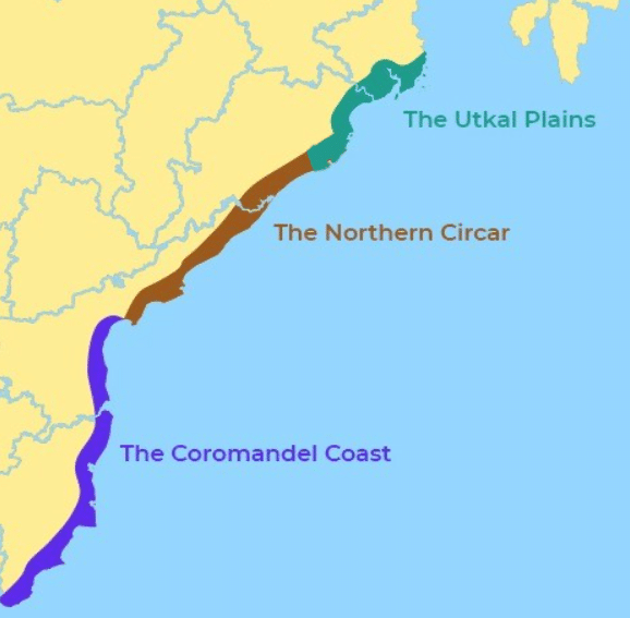
The maximum extent is 65 Km Maximum extent is 150-200 Km Dominated by Estuaries Dominated by Deltas The western coast is called a submerged coast. However, the Malabar coast is emergent one The entire Eastern coast is emergent The erosion process is more active The deposition process is active- So more beaches, sandbars The western coast is a broken coast or an Indented coast The eastern coast is smooth. The coastline is smooth Natural harbours and ports because of the broken coast and erosion. Few of them are Natural harbours but most are artificial/ man-made port Wider continental shelves around the western coast Narrow continental shelves around the eastern coast Kathiawad coast, Konkan coast, Malabar coast

Utkal plain, Northern circar, Coromanadal coast
The topic for the next class:- Drainage systems and Islands